Presidential Traverse

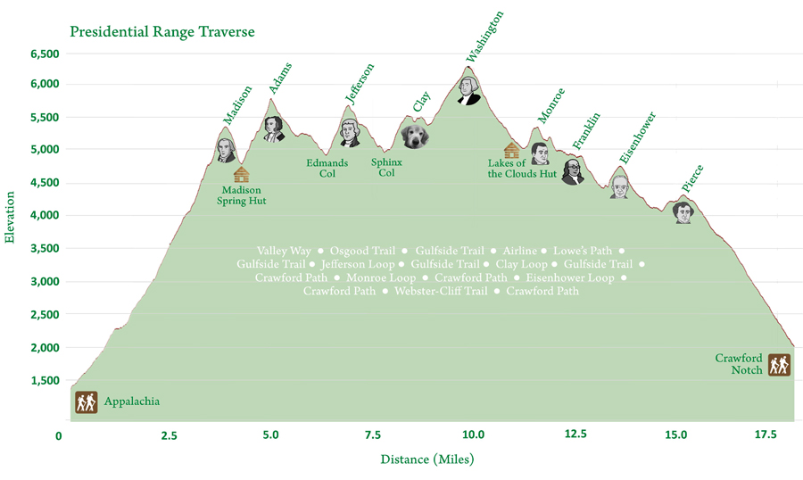
My friend June decided to go with me on a backpacking trip to the presidential traverse last summer. We didn’t have an early start and we got lucky we were able to ride the bus to take us to the trail head. We got there at 10am and we started hiking until 10pm all the way to the Lakes of the Clouds Hut, a shelter few miles away from Mount Washington. We were lucky the warden was kind enough to let us in the hut, because the wind picked up overnight.

Just to give you a background about the hike, the Presidential Traverse is a strenuous and sometimes dangerous trek over the Presidential Range of New Hampshire’s White Mountains. The Presidential Range is a string of summits in excess of 4,000 feet (1,200 m) located in the White Mountain National Forest all named after previous U.S. presidents. To complete the traverse, you must begin at either the northern or southern terminus of the Presidential Range and finish at the opposing end. The journey begins at the northern end at Mount Madison followed by Mount Adams, Mount Jefferson, Mount Washington, Mount Monroe, Mount Eisenhower and finally Mount Pierce.

The basic Presidential Traverse begins from a trail head on U.S. Route 2 or at the Dolly Copp Campground at the northern end of the Presidentials, crosses the great ridge of the range and ends in Crawford Notch at its southern terminus, or vice versa. The Presidential traverse is around 23 miles (37 km), with 9,000 feet (2,700 m) of elevation gain. The total distance could be shortened to 19.2 miles (30.9 km) by only taking standard through trails without summiting all the peaks.

By definition, a “presidential” traverse requires a hiker to cross over the summits of peaks named after U.S. presidents. Listed from north to south, they are:

Mount Madison – named after James Madison
Mount Adams – named after John Adams
Mount Jefferson – named after Thomas Jefferson
Mount Washington – named after George Washington
Mount Monroe – named after James Monroe
Mount Eisenhower – named after Dwight Eisenhower
Mount Pierce – named after Franklin Pierce
 

Spy Rock


Ok, I learned a few lessons here as far as excessive shaking while hiking using my Go Pro camera. I shouldn’t mount my camera on my backpack without a gimbal to stabilize the footage. I also need to be steady and slow down when I take videos on the trail. Hopefully, I get better the more I do this, but its a learning experience.

Anyways, hiking Spy Rock was a lot of fun on the Appalachian trail. Spy Rock is an incredible rock dome on the east side of Maintop mountain with 360° views of the Religious Range (The Priest, The Little Priest, The Friar, The Little Friar, and The Cardinal), Mt. Pleasant, Tree Ridges and St. Mary’s Wilderness areas, and the eastern foothills. We hike Spy Rock from the Meadows Lane parking Lot, but make sure you have a capable 4X4 vehicle to drive to the parking lot. There road was very rugged and there were two small water crossing before the parking lot. You can definitely get there with a car, but I don’t recommend going there with a 2 wheel drive.

The hike is part of the George Washington and Jefferson National Forest, and can easily be combined with the nearby Crabtree Falls (300ft cascading waterfall with a hike to the top). There are nice campsites at the base of the summit (no water source). I recommend combining Crabtree and Spy Rock in one hike if you have the time. It was never too crowded despite having probably the best 360 views of the Blue Ridge mountains. The spring and fall season are the best time to see the flowers and the fall foliage. I definitely enjoy this hike, but its quite a long drive from Maryland.

Patapsco Valley State Park Avalon Area


Ok, I go to Patapsco Valley State Park all the time, because its near my house. I used to hike with my dog Dodger, so what better way to start my second vlog. This is also my first chance to test drive my Go Pro Hero camera.

I just want to give a quick background on this park. Patapsco Valley State Park is a public recreation area extending along 32 miles of the Patapsco River south and west of the city of Baltimore, Maryland. In 2006, it was officially celebrated as Maryland’s first state park and is managed by the Maryland Department of Natural Resources.

There are 3 cool areas to visit at this park. The Bloede Dam, Cascade Falls and the Swinging Bridge. The Bloede Dam was currently under construction to be removed to improve public safety. The removal of that dam should allow migration of herring and eels and increase recreational opportunities on the Patapsco River. It should allow for better and safer fishing and swimming area. The best part of this park is Cascade Falls on the opposite side of the swinging bridge. It gently descends a 10-15-foot face and can be reached by way of a marked trail at the last parking lot on the Orange Grove area. The swinging bridge is on the opposite side of the parking lot that crosses the Patapsco river connecting Elkridge to Catonsville.

My First Vlog! Maryland Hiker

I finally decided to do a vlog. I do a lot of hiking, camping and backpacking every year around my area. I usually take videos, but I always ended up not doing anything with it. I have a lot of videos of my backpacking trip that I might be able to use. Let me be honest, I really have no idea what I’m doing as far taking videos and editing, but the best teacher in life is experience. I hope to share my love of nature and just being outdoors. I want to encourage people to try and not be intimidated by hiking, backpacking or camping.

Join our meetup group Maryland Hiking Group!

in Vlog | 113 Words